

Summary
The Hurricane Matthew Disaster Recovery and Resilience Initiative (HMDRRI) involves the university engagement of faculty and students as well as professional planning experts in addressing community and state-level needs associated with recovery from Hurricane Matthew.
The initiative’s objectives were to:
- Serve as point of contact for UNC faculty, students, and staff to help the state address a range of policy and technical issues as identified.
- Engage with select communities to assist them in identifying local needs and help them develop post-disaster recovery plans.
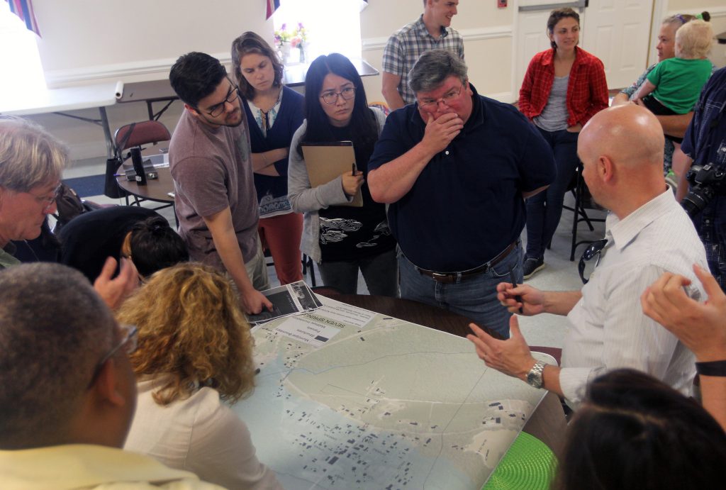
Our engagement with each community is tailored to match community-identified needs. Through community meetings, followed by smaller community discussions, the HMDRRI team will work with residents across all six communities to discuss the recovery planning process and its benefits, determine needs and opportunities, as well as identify a community vision, or set of goals for desired outcomes. From these meetings, HMDRRI planners will work with community leaders and residents to draft strategies, present a draft of the recovery plan back to the communities and finally, approve the recovery plan to help each community identify ways to build a resilient future.
Investigator

North Carolina State University
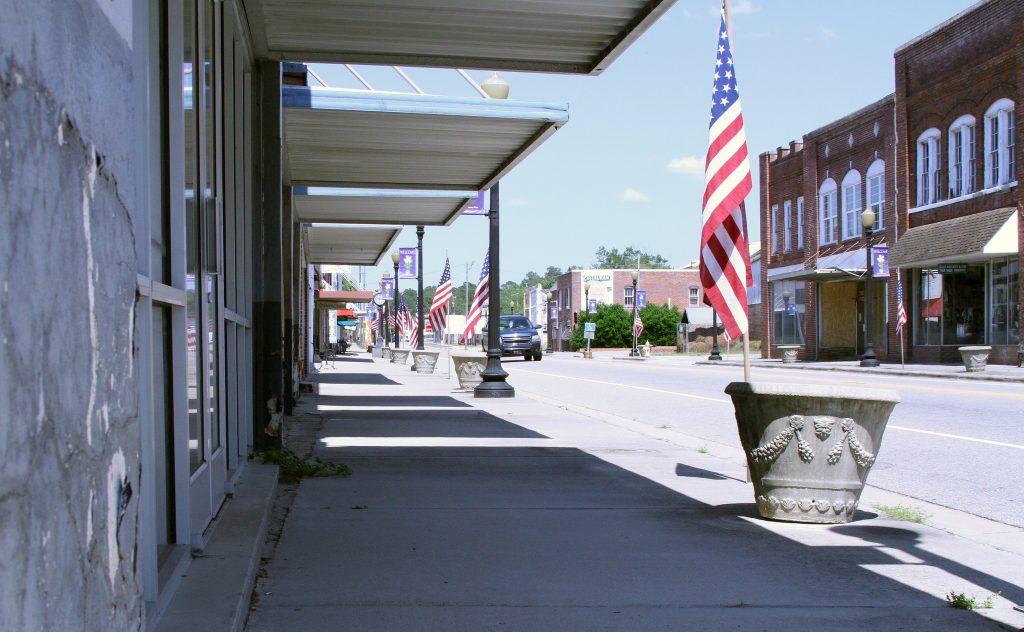
Fair Bluff
Fair Bluff, a town of fewer than 1,000 people along the Lumber River in Columbus County, N.C., sits near the North Carolina-South Carolina border. Built in 1873, the town’s prominent features include an elevated riverwalk along the Lumber, with main street one block away. Hurricane Matthew damaged approximately 100 homes out of fewer than 600 total housing units. Much of the town lies within the 100-year floodplain.
On Oct. 13, 2016, floodwaters from Hurricane Matthew moved downstream toward the eastern coast of North Carolina, causing the Lumber River to rise approximately 15 feet.
The North Carolina State University College of design proposed multiple housing types for relocation, elevation and further protection of future structures in town, as well as greenspace designation, through the Homeplace document.
Fair Bluff Reports
- Recovery Plan
- Homeplace
- Downtown Flood Retrofit Report
- Land Suitability Analysis Briefing | Technical Memo
- Market and Financial Analysis
Fair Bluff Recovery in the News
- NCSU class unveils options for rebuilding Fair Bluff by Allen Turner // The (Columbus) News Reporter (10.2.17)
- Fair Bluff Visioning Meeting by The News Reporter (video) (8.15.17)
Kinston
Kinston, N.C., is a city of more than 21,000, in Lenoir County, located along the Neuse River. Hurricane Matthew damaged about 200 homes, out of a total of 11,000 housing units. On Oct. 14, 2016, the Neuse River rose to 28 feet, twice as high as flood stage.
Much of the town lies within the 100-year floodplain, and Kinston was seriously impacted by Hurricane Fran in 1996 and Hurricane Floyd in 1999. FEMA and the state of North Carolina bought out properties in the 100-year floodplain, which extended about 3/4 of a mile into town from the river. Once acquired, the homes are demolished and the land maintained as open space in perpetuity. The funds provided to residents can be used to purchase a home located outside the floodplain.
In the intervening years, some former residential streets have remained blocked, and proposed uses such as parkland have largely stalled. Other flooded areas of the town have been converted into a park and nature center, and a large dog park complex, among other uses.
The North Carolina State University College of Design proposed multiple housing types for relocation, elevation, and further protection of future structures in town, as well as greenspace designation, through the Homeplace document.
Kinston Reports
- Homeplace
- Land Suitability Analysis Briefing | Technical Memo
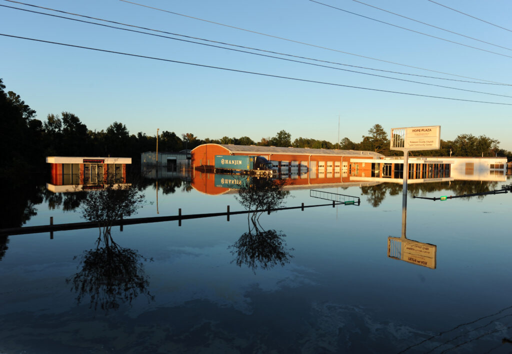
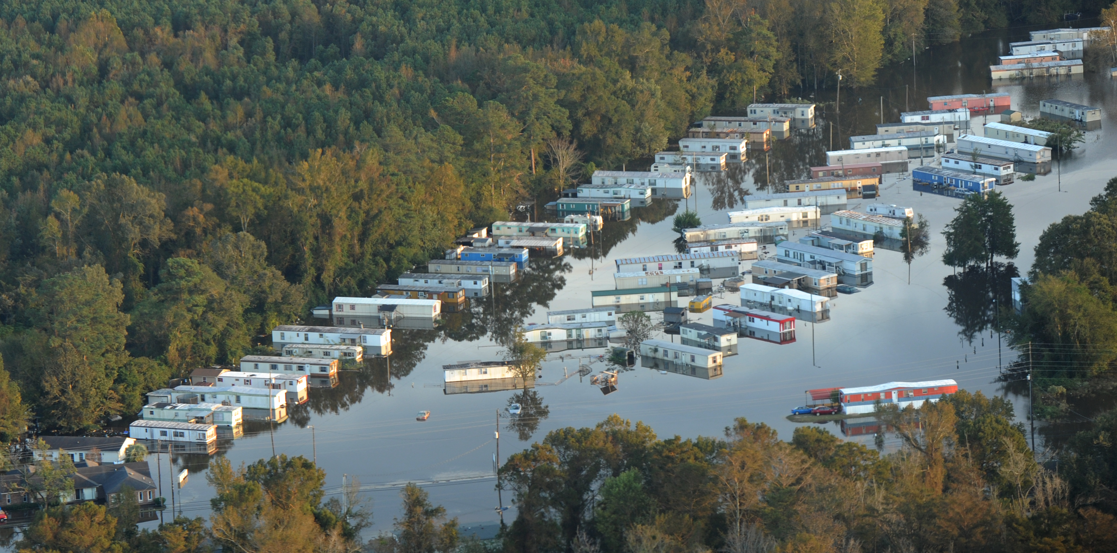
Lumberton
Lumberton, N.C., is a city of nearly 22,000 people in Robeson County, along the Lumber River in southern North Carolina. Among the city’s attractions is the Lumber River State Park, capitalizing on the proximity to the waterway. Hurricane Matthew destroyed about 400 homes out of more than 8,500 housing units.
Princeville
Princeville, N.C., is a town of about 2,200 people, pre-Hurricane Matthew. About 450 homes were destroyed during the hurricane and subsequent flooding, and an estimated 80% of the town was underwater.
Founded in 1865 as Freedom Hill, Princeville is the first town founded by freed slaves in the United States. Though surrounded by a levee built in the 1960s, Princeville was affected by two storms less than 20 years apart that overtopped those defenses: Hurricane Floyd in 1999 and Hurricane Matthew in 2016.
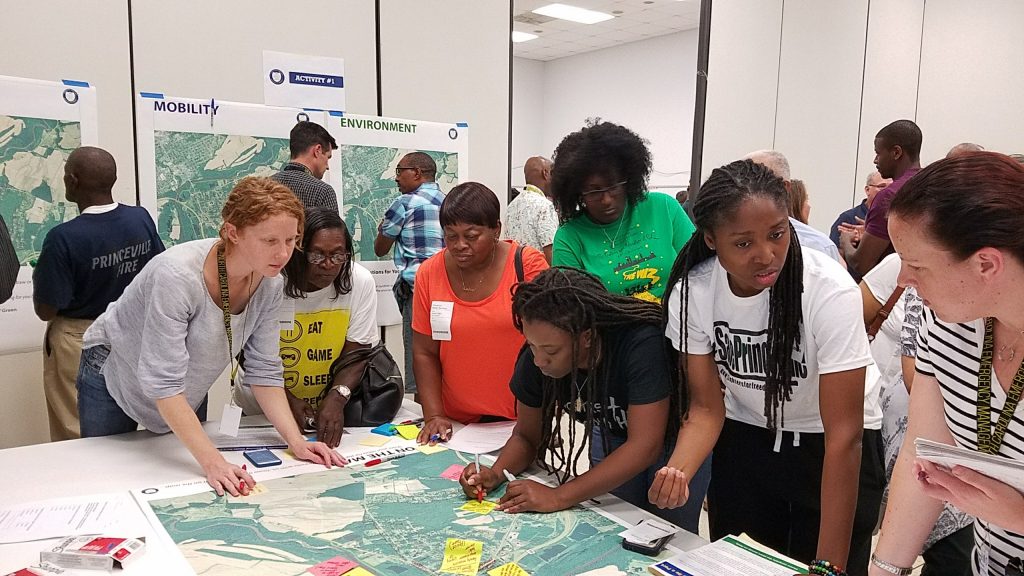
Community Design Workshop
Several hundred Princeville residents who attended a multi-day Community Design Workshop, held Aug. 25-29 in neighboring Tarboro, to design a plan for a more flood-resilient future. The event was co-sponsored by the town of Princeville, Edgecombe County, University of North Carolina at Chapel Hill’s (UNC-CH) Coastal Resilience Center of Excellence (CRC), North Carolina State University (NCSU) College of Design, North Carolina Emergency Management and the (N.C.) Governor’s Recovery Office. This five-day workshop brought together teams of land use planners, engineers, architects and landscape architects to collaborate with local, state and federal officials to develop three scenarios for a new 52-acre tract of land that the state intends to buy. The parcel will include houses, businesses, infrastructure, public facilities and community open space in ways that ensure that the new space connects physically, socially, environmentally and economically to historic portions of town. Located outside of the floodplain, the new space would make the town more resilient to future flooding.
Princeville Reports
Princeville Media Coverage
- UNC center helps historic town rebuild after hurricane by Jay Siebold // Carolina Connection (10.28.17)
- Saving Princeville by The University of North Carolina (10.19.17)
- One year on, Hurricane Matthew is still drowning communities with dilemmas by Tyler Newman // The Seahawk (10.18.17)
- Recovery in North Carolina one year later by Jim Schwab // jimschwab.com (10.14.17)
- Princeville works to save homes and history one year after Hurricane Matthew by Leoneda Inge // WUNC (10.6.17)
- Some N.C. towns struggle to survive a year after Matthew by Jay Price // WUNC (10.4.17)
- Princeville Community Design Workshop (video) by the N.C. Rural Center (10.3.17)
- After two floods, historic African-American town could move to higher ground by Colin Campbell // The News & Observer (9.29.17)
- Landscape architecture professor talks hurricane relief, rebuilding Princeville by Timothy Willard // Technician (9.28.17)
- In this N.C. town, a model for rebuilding is taking shape by Josh Cohen // Next City (9.21.17)
- Hurricane Matthew Infographic (updated) by UNC Office of Research Communications (9.21.17)
- Princeville Community Design Workshop by UNC Research (9.15.17)
- Saving Princeville by NC State News (9.12.17)
- Princeville wraps up revitalization workshop by Emily Gibbs // WNCT (8.29.17)
- Princeville residents get a glimpse of new plans after Hurricane Matthew by Michael Hyland // WNCN (8.29.17)
- 52-acre would add land less flood-prone to Princeville by Adam Owens // WRAL (8.29.17)
- Teams develop plans to make Princeville less vulnerable to flooding by Adam Owens // WRAL (8.29.17)
- Design workshop aims at making plans for North Carolina town by WRAL (8.26.17)
- Princeville partner with design teams to limit flooding in the future by David Hurst // WNCN (8.25.17)
- Princeville kickstarts Hurricane Matthew revitalization by Emily Gibbs // WNCT (8.25.17)
- Design teams gather to plan Princeville’s future by North Carolina Department of Public Safety (8.22.17)
- Princeville steps up recovery efforts after Hurricane Matthew by Rebecca Martinez //WUNC (7.20.17)
- Princeville to host events focused on recovery efforts by Corey Davis // Rocky Mount Telegram (7.20.17)
- First in Future: NCSU Associate Professor of Landscape Architecture and Co-Director for Coastal Dynamics Design Lab Andrew Fox by Institute for Emerging Issues (7.11.17)
Seven Springs
Seven Springs, N.C., is a small town of 76 people in eastern Wayne County, along the Neuse River. Hurricane Matthew damaged almost all of the homes and most of the businesses in town.
The North Carolina State University College of design proposed multiple housing types for relocation, elevation, and further protection of future structures in town, as well as greenspace designation, through the Homeplace document.
Seven Springs Reports
Media Coverage
- Residents look at possibilities for Seven Springs by Steve Herring // The News-Argus (10.15.17)
Windsor
Windsor, N.C., is a town of about 3,600 people along the Cashie River, in Bertie County in northeastern North Carolina. Parts of the town lie in the 100-year and 500-year floodplain.
Hurricane Matthew damaged about 60 homes, out of about 1,110 total housing units. On Oct. 9, 2016, the Cashie rose to 17 feet, more than double its flood stage.
The North Carolina State University College of design proposed multiple housing types for relocation, elevation, and further protection of future structures in town, as well as greenspace designation, through the Homeplace document.
Windsor Reports
- Flood Retrofit Report
- Homeplace
- Land Suitability Analysis Briefing | Technical Memo
- Market and Financial Analysis
Media Coverage
- Despite regular flooding, Windsor community spirit won’t sink by WRAL (10.10.17)
Resources
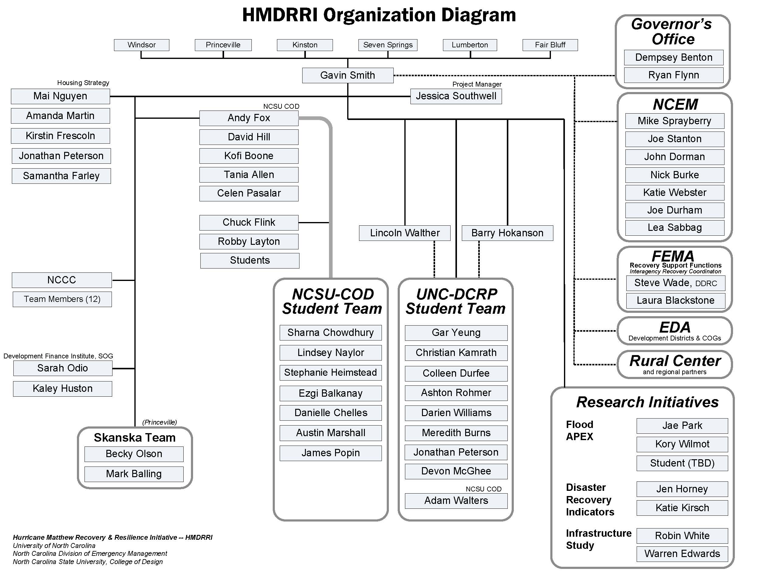
- HMDRRI Organizational Chart
- HMDRRI Phase One Report (October 2017)
- Hurricane Floyd/Hurricane Matthew Empirical Disaster Resilience Study
- Affordable Housing Strategy for Eastern North Carolina
- HMDRRI Phase One Funding Report (UNC Policy Collaboratory)
- Hurricane Matthew Infographic (UNC-Chapel Hill Office of Research Communications)
- Community Resilience-Focused Technical Investigation of 2016 Lumberton, North Carolina Flood (NIST)
- About the Homeplace project
- Federal Emergency Management Agency: Hurricane Matthew resources (North Carolina)
- North Carolina Department of Public Safety: Hurricane Matthew 2016 | Storm Stats
- Carolina Center for Public Service Hurricane Matthew Disaster Relief Information | Relief Trips
- NC Rural Center Small Business Recovery Fund
- Map of six communities that are the focus of the Hurricane Matthew Disaster Recovery and Resilience Initiative (Credit: The News & Observer)
Acknowledgements
Members of the Initiative would like to thank the following organizations for their gracious support of our work through funding, staff support, data, office space, and other resources:
- North Carolina Policy Collaboratory
- North Carolina Division of Emergency Management
- North Carolina State Legislature
- U.S. Department of Homeland Security, Science and Technology Directorate
- Office of University Programs
- Flood Apex Program
Without their support, we would not be able to provide a sustained level of assistance to these six communities.